GAGAN
AIBM
April - June 2017
GAGAN is set to broaden the horizon for civil aviation
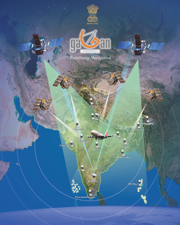
The GAGAN system is a SBAS developed jointly by AAI and ISRO and certified by DGCA for RNP 0.1 (enroute) operations over Indian Flight Information Region (FIR) and covering most of the Indian Landmass for APV 1 operations since April 21, 2015, with expansion capability to neighbouring FIRs.
The GPS Aided Geo Augmented Navigation (GAGAN) provides a civil aeronautical navigation signal consistent with International Civil Aviation Organisation (ICAO) standards and Recommended Practices (SARPs) as established by the Global Navigation Satellite System (GNSS) Panel. It is the fourth Space Based Augmentation System (SBAS) in the world in addition to Wide Area Augmentation System (WAAS) from United States (US), European Geostationary Navigation Overlay Service (EGNOS) from Europe, and Multifunctional Transport Satellite (MTSAT) Satellite Augmentation System (MSAS) from Japan, third such system that has the capability of Approach with Vertical Guidance (APV), providing near precision vertical guidance to most of the runways up to Obstruction Clearance Altitude (OCA) of 250ft and the first SBAS developed for meeting the requirements for equatorial anomaly region.
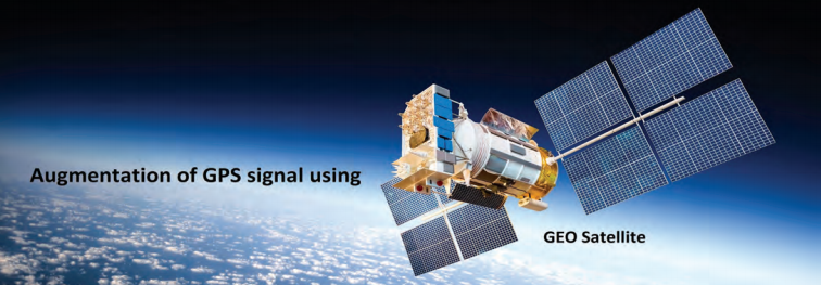
GAGAN is a part of Global Navigation Satellite System (GNSS), which takes the navigational aid from the core GPS (Global Positioning System) constellation and augments it through the GEO stationary satellite for providing better accuracy, integrity and continuity of service for its application in civil aviation.
GAGAN signals are compatible with international SBAS interoperability standards; ICAO SARPS (International Civil Aviation Organisation ‘Standards and Recommended Practices’) on GNSS and MOPS (Minimum Operational Performance Standards) established by the Radio Technical Commission for Aeronautics (RTCA).
Aviation Applications
Today, GAGAN is operational and offers two levels of services; RNP 0.1 (Required Navigation Performance 0.1) over Indian Flight Information region and APV I (Approach with Vertical Guidance, Level I) over most of the Indian landmass, to its aviation users. As the GAGAN signals can be decoded by any SBAS enabled receivers, non-aviation users can also take the advantage of more accurate and reliable positioning information, available from GAGAN.
GAGAN is certified for all phases of flight specifically qualified as Approach with Vertical Guidance (APV1) for landing phase, which will provide the real impact to aviation as multiple runway ends will have straight in, near precision approaches with vertical guidance, thereby, enhancing the safety by 25 times in the crucial phase of flight. Vertical guidance (APV) available on all runways (CFIT reduction) and low height routes (helicopters, obstacles).
It also provides low cost, high performance avionics for all users and has the potential to rationalise conventional navigation aid infrastructure. It offers a backup to Instrument Landing System (ILS) approaches, lowers operational minima on non-ILS runways, has advanced procedures for curves, has lower noise impact, and render more efficient routes and fuel savings. Operation in areas with poor navigation infrastructure is an added benefit. As for helicopter navigation, GAGAN caters to offshore operations, rough terrain operations, emergency medical requirements and search and rescue services.
Some of the advantages of GAGAN are that it doesn’t depend on ground navigation infrastructure at heliports or Visual Flight Rules (VFR) operations, reduces the decision height and provides accessibility under poor weather conditions. The most important and beneficial application of GAGAN in aviation is the possibility to allow the aircraft to perform approaches with vertical guidance (LPV approaches) with no need of ground navigation aids infrastructure. Due to the lower cost of the required on-board avionics equipment to perform these approaches, it is better suited for regional aviation, general aviation and helicopters.
Non-Aviation Applications
Although primarily meant for civil aviation, the GAGAN signal can be used by a vast majority of civilian and non-aviation users. GAGAN will provide benefits beyond aviation to many other user segments, such as intelligent transportation, search and rescue, seaways, highways, railways, surveying, geodesy, security agencies, real time weather forecasting, land management through terrestrial mapping, marine mapping, precision farming, telecom industry, personal users of position location applications and several other research applications, within the Indian subcontinent.

Road and rail transportation will benefit immensely from GAGAN
Road and Rail
GNSS-enabled applications in surface transportation provide different benefits to end users, including improvements to productivity, safety and the monitoring of operations and goods. Today, the adoption of GPS technology is growing quickly for various commercial applications as tracking/ tracing vehicles that transport goods (for safety and surveillance purposes) and for monitoring service fleets, etc. Fleet management application requires installation of onboard units, which transmit GNSS positioning information through telematics to support transport operators in monitoring the performance of logistics activities.
Another application of GAGAN in surface transportation could be implementation of smart highways, where vehicular movement information can be obtained through GNSS based portable navigation devices, in-vehicle navigation systems or mobile devices. Collected information can be further processed for distribution among general public, road patrolling units or law enforcement agencies for various purposes. GAGAN-based applications can also be developed for railways, like command and control of trains, collision avoidance system, real-time display of a train’s position etc.
Shipping Vessel position accuracy within eight to 20 metres at harbours and within 450 metres in coastal waters, with an availability figure of greater than 99 pc, can be considered as the typical requirement in shipping industry. GAGAN can easily meet these requirements of accuracy with high reliability.
GAGAN Message Service (GAMES)
Airports Authority of India (AAI) in coordination with Indian National Centre for Ocean Information Services (INCOIS), Snow and Avalanche Study Establishment (SASE), National Disaster Management Administration (NDMA), and Indian Metrological Department (IMD) is planning to utilise GAGAN in disaster management, precision agriculture, fisheries, etc. To achieve this, a concept of Short Message Service (GAMES) using GAGAN is being evolved and will be implemented soon, which will provide specific, reliable alert messages to various users.
The applications of GAGAN to various users are enabled through the GAGAN messages sent through the GEO satellites (GSAT-8 and GSAT-10). Further GAGAN can be utilised for sending short service messages with suitable changes in the message structure. In this context, the availability of free bandwidth enables systems like GAGAN to broadcast additional communication messages. Early warning messages on the occurrence of natural disasters, calamities and dangers for the safety of life within GAGAN coverage area also add value to lives and goods. Search and rescue messages, relief and mitigationrelated messages and meteorological information are some more benefits of GAGAN.
GAGAN footprint covers a vast area from South Africa to Australia and can be utilised very effectively in the Asia-Pacific region.
Service Expansion
Currently, India is looking for opportunities for the expansion of GAGAN service beyond its territorial boundaries, as the footprint of GAGAN has the potential to provide services from Africa to Australia. In that quest, AAI has taken up the issue with most of the countries through ICAO, Directorate General of Civil Aviation (DGCA) and informal meetings with BOBASIO (Bay of Bengal, Arabian Sea, Indian Ocean) states. Nepal, Bangladesh, Sri Lanka and other SAARC countries can derive maximum benefits from GAGAN, as the footprint covers them efficiently. The number and mode of operations can be worked out mutually.
AAI, with support from USTDA (under US-India Cooperation Programme) has taken up business promotion and expansion of GAGAN in the Asia-Pacific region. The main focus of the programme is to study the advantage of GAGAN technology in aviation and non-aviation sectors and develop opportunities for assistance programmes in neighbouring countries, such as Bhutan, Afghanistan, Nepal, Sri Lanka, Myanmar, Bangladesh, Maldives, etc., through the Ministry of External Affairs.
AAI along with Indian Space Research Organisation (ISRO) coordinated with states in Mid-East ICAO region. A team of Arab Civil Aviation Commission (ACAC) visited GAGAN Bengaluru on the feasibility of GAGAN service in ACAC region.
India is coordinating with Sri Lanka for expanding cooperation in the aviation sector by building capacity for aircraft accident investigation, aeronautical SAR, use of Indian Satellite System GAGAN, sharing of training opportunities etc.
With the advent of GAGAN, navigation is expected to scale newer heights
Challenges
The ionosphere is the biggest source of error in satellite-based navigation systems such as GPS, IRNSS, SBAS, GALILEO, GLONASS, etc., since it introduces delays in the Radio Frequency (RF) signal travelling from satellite to ground. The ionospheric region starts from around 100 km above the earth’s surface and extends till around 1,000 km. The RF signal delay is proportional to the electron density present in the line of sight in the ionosphere. Theoretically, the maximum electron density should be at the magnetic equator and decrease monotonically as we go northwards or southwards. However, there exists an anomaly known as Equatorial Ionization Anomaly (EIA), in which, two crests of electron density over ±15 degrees from magnetic equator and a trough over magnetic equator is formed. Incidentally, India lies in this anomalous ionospheric region, as magnetic equator crosses through southern tip of India and crest is formed at about 23 degree latitude. The region above 30 degree is considered to be a calm and quiet ionospheric region. The anomalous ionosphere is characterised by high electron density, steep electron density gradients, depletions (plasma bubbles) and scintillations, which cause various problems in satellite-based navigation.
AAI, in association with ISRO, established the GAGAN ionospheric monitoring network, consisting of dual frequency GPS receivers at 25 airports, in order to study and develop the ionospheric model for GAGAN. An IGM-MLDF model was developed, which provides ionospheric vertical delay at pre-defined grid points spaced at 5×5 degree latitude/longitude. GAGAN has been commissioned and certified for enroute and APV I precision approach services, thus, providing seamless navigation of aircraft from takeoff to landing.
Uniqueness
GAGAN is the first satellite-based navigation system in the world that has been developed and implemented successfully over the equatorial region (India) to provide RNP 0.1 (enroute) and APV 1 (Approach with Vertical Guidance) service to the users.