Exponential growth in civil aviation in terms of increasing passengers, induction of new planes, terminal building of new airports and renovation of abandoned air strips has given rise to many challenges. Maintaining safety in the skies is one such complex issue.
How safe is flying? This question flashes in our minds every time we fly or read about incidents involving air safety, particularly accidents involving commercial flights.
Boom Time
Passenger traffic continues to boom. According to the preliminary figures released by the International Civil Aviation Organisation (ICAO) in January, 2018, a record 4.1 billion passengers were carried by the aviation industry on scheduled services in 2017. This indicates a 7.1 percent increase over 2016. The number of departures rose to approximately 37 million globally, and world passenger traffic, expressed in terms of total scheduled Revenue Passenger-Kilometres (RPKs), posted an increase of 7.6 percent with approximately 7.7 trillion RPKs performed. This growth is a slight improvement from the 7.4 percent achieved in 2016.
India, which is at the cross-roads of modernisation of its civil aviation infrastructure, also witnessed similar robust growth in terms of air passengers.
According to the data released by the Directorate General of Civil Aviation (DGCA), domestic airlines flew 117.17 million passengers during 2017, surpassing the 100-million mark for the first time. This is a growth of 17.3 percent from 99.88 million domestic flyers in 2016.
ICAO Council President, Dr Olumuyiwa Benard Aliu observed: “The sustainability of the tremendous growth in international civil air traffic is demonstrated by the continuous improvements to its safety, security, efficiency and environmental footprint. This sustainability is the result of concerted efforts and cooperation at the national, regional, and global levels, particularly in terms of ICAO compliancy, which is key to accessing the global network.”
2017: Safest Year
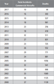
Another bonanza was that 2017 was the safest aviation year in recent years. The Aviation Safety Network (ASN) pointed out that year 2017 recorded a total of 10 fatal airliner accidents resulting in 44 occupant fatalities and 35 persons on the ground. This makes 2017 the safest year ever, both in terms of the number of fatal accidents and fatalities. In 2016, ASN recorded 16 accidents and 303 lives lost.
According to Air Safety Network President Harro Ranter, the low number of accidents comes as no surprise. “Since 1997 the average number of airliner accidents has shown a steady and persistent decline, thanks to the continuing safety-driven efforts by international aviation organisations, such as ICAO, IATA, Flight Safety Foundation and the aviation industry”.
Robust Growth
India is the third largest and the fastest growing domestic aviation market in the world in terms of number of domestic tickets sold. In 2016–17, annual growth in domestic passenger departures was 23.5 percent as compared to 3.3 percent in the US and 10.7 percent in China.
As per the data released by the Directorate General of Civil Aviation (DGCA), Indian carriers registered about 24.14 percent growth in passengers flown during February compared to a year ago. Indian carriers carried 10.7 million passengers during the month, up from 8.6 million in February 2017. Compare this to a mere 44 million Indians who travelled by plane in 2008.
These numbers may look big. But the real growth is yet to come as only 5 percent out of the 1.3 billion Indians travel by air. Minister of State for Civil Aviation Jayant Sinha laid out ambitious plans for a five-fold increase in passenger trips to one billion per annum in the 15–20 years’ time frame. “A goal of a billion passenger trips in the next 15 to 20 years is very realisable, and is in fact a realistic target that we should be looking at,” the minister said.
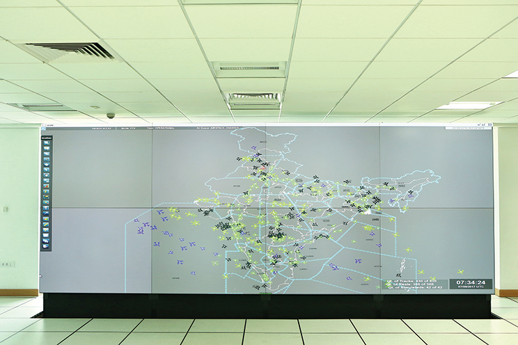
Depiction of air traffic movement over the Indian airspace
Emerging Challenges
As passenger growth continues to soar to new heights, the question that arises is how safe is flying? Compared to other modes of transport, such as rail or road transport, air travel is safest across the globe and also in India. When measured against the number of air travellers, the number of deaths from air crashes is minuscule.
India witnessed as many as 375 air-safety violations in 2017 as compared to the 431 reported in 2016.
“The number of air-safety violations is definitely alarming, but is also an indicator of the increase in aviation activity without a significant increase in the infrastructure. Most of our large airports are operating at capacity or are reaching peak capacity. The numbers of aircraft are steadily increasing and the number of flying passengers has gone up exponentially. India is initiating measures to reduce this infrastructure congestion (secondary airports, increasing terminal and runway capacity, among others) and is also trying to spread aviation to distant corners of the country,” aviation expert, Amber Dubey points out.
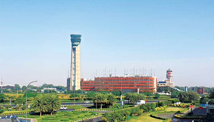
What is more important is how infrastructure, such as air navigation system is making it safe for us? Realising the emerging challenges, the Airport Authority of India (AAI), as the lead air navigation service provider (ANSP) in the country is undertaking several initiatives.
Stakeholders know that every fatality is a tragedy. In their common goal for every flight to take off and land safely, the AAI is adapting new technologies.
How big is the Indian airspace? The AAI provides navigation services over Indian territorial airspace and also over the Bay of Bengal, Arabian Sea and Indian Ocean Region, which is about 2.8 million sq. nautical miles. The entire Indian continental and oceanic airspace is being controlled by seven Area Control Centres, three Oceanic Control Centres and eight Lower Area Control Centres.
“Immediate challenges for AAI as ANSP are to manage the exponential growth in traffic safely. This includes reducing the impact of aircraft noise on local communities; ensuring reduced fuel burn by improving flight profiles; supporting new-generation aircraft by modernising Air Traffic Management (ATM) systems; possibly increasing the use of drones; transitioning to a trajectory-based concept, where present and intended aircraft positions will be known with higher degrees of accuracy; and to select and absorb the right technologies,” says A K Dutta, Member (ANS), AAI.
Significantly, AAI has developed Air Navigation Services (ANS) strategic plan in line with ICAO’sGlobal Air Navigation Plan (GANP) for the period 2016-2030, which provides guidance to increase the capacity and improve the efficiency of the global civil aviation system. The GANP applies a rolling 15years strategic methodology to support a globally harmonised air navigation services. It guides states in leveraging existing technologies and anticipating future developments based on operational objectives agreed by the state in consultation with industry. This is done through a series of Aviation System Block Upgrade (ASBU), a methodology that allows states to advance their air-navigation capacities based on their specific operational requirements.
Dutta asserts that India has already commenced the implementation of a number of technologies and practices contained in Block 1 of ASBU (up to 2019).
Navigation Aids
Besides these, India has been using several navigational aids to smoothen its air-traffic operations to safety.
The current navigation infrastructure comprises primarily of ground-based navigation aids, such as Non-Directional Beacon (NDB), Doppler Very High Frequency Omni Directional Range (DVOR), Distance Measuring Equipment (DME) and Instrument Landing System (ILS) radio aids, which are standard International Civil Aviation Organisation (ICAO)-based navigational and precision landing aids. Performance-based navigation (PBN) implementation in India commenced in 2007.
NDB is a standard International Civil Aviation Organisation (ICAO) ground-based radio navigational aid used by aircrafts to help obtain a fix of their geographic location on the surface of the Earth. According to Dr Arjun Singh, Managing Director, Shakti Aviation Consultancy and a leading aviation consultant, NDB is obsolete but is being procured more due to the regional connectivity scheme to reduce the navigation infrastructure cost and make RCS viable proposition. But he is quick to point out that India keeps on replacing the old equipment, which has been in service for more than 15 to 20 years.
The Next Level is the Instrument Landing System (ILS).
The Indira Gandhi International Airport is the first airport in the country to offer Low Visibility Procedure (LVP) operations supporting up to CAT III B capability with support of Three ILS. Lucknow and Jaipur airports have also been upgraded to support CAT IIIB operations. AAI, which manages 125 airports in the country, is now planning more airfields to be CAT III compliant. It will help maintain smooth operation of aircrafts during foggy conditions.
Charting a New Course
With mounting pressures on aviation infrastructure, AAI has also turned to adapting new technology. One such initiative is the Ground-Based Augmentation System. Honeywell’s SmartPath technology for satellite-based precision approach and landings was installed at Chennai International Airport, since 2013 under the supervision of the Airports Authority of India. It is the first GBAS certified by the Federal Aviation Administration (FAA) in the world. With the increasing number of passengers across India expected to reach 540 million annually, by 2025, SmartPath can support the growing demand at Chennai International Airport by helping aircraft avoid air traffic. The advantage of GBAS is the simultaneous support for multiple runways and one system is capable of providing precision approach to fifty runways. So number of ILS not required at the multiple runways like Delhi, Mumbai, Chennai & Kolkata. The GBAS provides multiple approaches. This, in turn, will reduce delays and journey times for passengers, lower operational costs for airlines and reduce consumption of fuel.
But GBAS is yet to be fully implemented in India. Dr Arjun Singh points out: “The Directorate General of Civil Aviation, which is the regulator in India has not approved it yet.”The DGCA has to know the working system of this cutting-edge air navigation technology. “Approval involves two significant issues. First, it involves framing the regulations. Secondly it has to work on flight calibration crtification.”
India Joins Elite Club
Another state-of-the art technology in air navigation is GPS Aided Geo Augmented Navigation (GAGAN) over the Indian region. India took an early initiative and put in place its own Satellite-Based Augmentation Systems (SBAS). It was visionary approach of AAI management (Government of India). The system was developed by the Indian Space Research Organisation (ISRO) and Airports Authority of India (AAI). Both the organisations reached an agreement in August 2001 for the establishment of the GAGAN System. Dr Singh acknowledges that when implemented, GAGAN will no doubt smoothen air navigation, restructuring Indian airspace to increase airspace capacity, space-based procedures design reduces the separation, providing seamless operation etc. “But the question is, when? It has already been 17 years since the agreement was signed between ISRO and AAI,” he points out.
India is the fourth country in the world, after USA, Europe and Japan, to take up the challenge of establishing the regional SBAS that will redefine the navigation over India and adjacent regions.
This coupled with Automatic Dependent Surveillance-Broadcast ADS-B (Out) will push the safety envelope across not only India but also across most parts of Africa, Asia, and Australia and can support seamless navigation across the Globe.
This satellite navigation technology removes the signal errors from Global Navigation Satellite Systems and provides highly precise navigation signals to users.
The Directorate General of Civil Aviation (DGCA) has issued a directive mandating GAGAN equipage on all Indian registered aircraft entering the country on or after 1 January, 2019. DGCA is also examining the feasibility of issuing a mandate for retrofitting of the current Indian registered aircraft. But who will bear the cost of retrofitting as it costs very heavily to airline operators?
Dutta asserts that AAI has started the next move to establish GAGAN procedures at all suitable runway ends that will allow Global Navigation Satellite System (GNSS) based approaches for suitably equipped aircraft. “GAGAN can be used as a primary means of navigation from takeoff through the category I precision approach. In the aviation field, GAGAN operations will support more direct airroutes, reduced separation standards, reduced fuel consumption and improved safety.”
AAI has also put a robust plan in place to provide required communication, navigation and surveillance/air-traffic management system infrastructure at all the green-field airports as per their respective regulatory and operational requirements. AAI has entered into a ‘CNS/ATM Agreement’ with the respective airport operator in case of Public-Private Partnership (PPP) airports.
Safest Year in Aviation History
Towards Seamless Skies
The Indian airspace is divided into five Flight information Regions (FIRs)— Chennai, Mumbai, Delhi, Kolkata and Guwahati. There are eleven area control centres (ACC) that have been established at Mumbai, Delhi, Chennai, Kolkata, Hyderabad, Ahmedabad, Nagpur, Mangalore, Thiruvananthapuram, Guwahati and Varanasi. Now, India is working on the consolidation of airspace and reduction in the number of FIRs. To this end, India has issued a tender to revolutionise the air traffic management.
The Ajay Prasad Committee in 2008 observed: “With the growth of air traffic there is a requirement globally for a seamless airspace, which is achieved through consolidation of airspace.”
An excellent example is that of Air Services Australia, which has an area which is two and a half times that of India. They have reduced six FIRs to just two FIRs and two ACCs. Even one ACC is capable of handling the entire air traffic of Australia but two are kept asbackup in case of emergency situations.
The Ajay Prasad Committee had suggested that it would be appropriate to consolidate the airspace to have two FIRs and two ACCs capable of handling the entire airspace of India independently. “In the event of a failure of one ACC, the design should permit the other ACC to takeover as a backup.”
No doubt, several steps are being undertaken to upgrade and modernise air navigation services in the country. It will not only help ease pressure on the aviation infrastructure but also keep India geared for the future.
A View from Above
There are half a dozen global safety nets for the skies being implemented by respective Air-Navigation Service Providers (ANSPs) of various countries. These nations are in the process of implementing space-based Automatic Dependent Surveillance (ADS-B). Here is a brief snapshot:
Nav Canada: It is Canada’s air navigation service provider (ANSP) managing 12 million aircraft movements a year for 40,000 customers in over 18 million square kilometres. Canadas’s airspace stretches from the Pacific West Coast to the east coast of Newfoundland and out to the centre of the North Atlantic, the world’s busiest oceanic airspace with some 1,200 flights crossing to and from the European continent daily. It also stretches from the busy US– Canada border with major international airports to the North Pole, where aircraft fly the polar routes to reach Asia.
NATS–UK: NATS (formerly known as National Air Traffic Services) is the UK’s leading air service provider of airtraffic control services. NATS handles 2.4 million flights and 250 million passengers in the UK airspace and is the sole provider of en route services there. It operates from two centres at Swanwick in Hampshire, England and Prestwick in Ayrshire, Scotland, serving 1200 oceanic flights per day.
CAA Singapore: The Civil Aviation Authority of Singapore (CAAS) will be the first ANSP in the Asia Pacific region to adopt space-based ADS-B, a service that will be operational later this year. Over the next two years, CAAS will be setting up the necessary infrastructure to integrate the service with air traffic control systems. When implemented, space-based ADS-B will provide continuous surveillance of ADS-B equipped aircraft in the Singapore FIR.
SCAA: The Seychelles Civil Aviation Authority (SCAA) covers 2.63 million sq. km. Most of it is oceanic airspace stretching to the borders of Kenya, Somalia, India, Mauritius, Madagascar and Tanzania.
Air Traffic& Navigation Services in South Africa provides air traffic, navigation, training and associated services within South Africa and a large part of the southern Indian and Atlantic Ocean, comprising approximately 10 per cent of the world’s airspace.
ASENCA: The Agency for the Safety of Air Navigation in Africa and Madagascar (ASECNA) is the largest ANSP in Africa covering 16.1 million sq.km of airspace spread over 17 states. It is divided into six flight-information regions— Antanavario, Brazzavile, Dakar Oceanic, Dakar Terrestial, Niamey and N’Djamena as defined by ICAO.
ADS-B: An Eye in the Sky
Automatic Dependent Surveillance– Broadcast (ADS–B) is a surveillance technology, wherein an aircraft determines its position via satellite navigation and periodically broadcasts it, enabling it to be tracked. The information can be received by air-traffic control ground stations as a replacement for secondary radar as no interrogation signal is needed from the ground. It can also be received by other aircraft in the vicinity to provide situational awareness and allow self-separation.
ADS-B affords benefits to flight crews, operators and air traffic controllers. With ADS-B fitted in an aircraft, a pilot is able to view traffic information about surrounding aircraft if those aircraft are equipped with ADS-B out. This information includes altitude, heading, speed, and distance to aircraft. Also, ADS-B is less expensive than radars, and therefore, benefits the system operators. It is cheaper to install and operate compared to primary and secondary radar systems used by Air Traffic Control (ATC) for aircraft separation and control. It also benefits aircraft operators, particularly passengers and freight carriers. Thanks to stringent and more efficient procedures to reduce the flying time significantly.
This results in saving fuel, flying time and maintenance costs. According to a study, if the North Atlantic region had ADS-B surveillance, operators could realise as much as USD 125 million a year in fuel savings! Consequently, it leads to reduced emissions, especially CO2. Reduced aviation fuel consumption equals lower carbon footprint.