
India’s defence space architecture integrates Earth observation, electronic intelligence, navigation and secure communication through multiple satellite systems
On the morning of May 7, 2025, as Indian armed forces executed strikes in Pakistan under Operation Sindoor, one technology worked in near-silence that would have been unavailable to Indian commanders 26 years earlier, during the Kargil War between India and Pakistan. NavIC, India’s indigenous. Navigation with Indian Constellation system, fed positional data to precision-guided munitions and drones with an accuracy of 10 to 20 centimetres. In contrast. during the 1999 conflict when India was fighting Pakistani-backed militants at Kargil, the United States had simply switched off India’s access to the Global Positioning Satellite system. That dependency no longer exists in the same form, though it has been replaced by vulnerabilities that defence planners are still working to close.
It was visible even during Operation Sindoor, when China proactively provided crucial satellite support to Pakistan. For instance, its BeiDou satellite navigation network was used by the Pakistan military to search, identify, and track targets on the Indian side of the Line of Control, while data from Chinese satellites was directly fed into the fire-control systems of Pakistani Chinese-origin fighter jets, such as the J-10C, to help guide advanced air-to-air missiles. Chinese satellites also helped Pakistan to continuously monitor Indian military deployments, infrastructure and troop movements.
Enroute but not yet arrived
The conflict last year showed that while India’s satellite warfare capabilities had improved significantly, the country still had a long way to go to reach anywhere close to China.
India’s satellite architecture for defence rests on three overlapping layers: surveillance and reconnaissance delivered through RISAT-2B, Cartosat-3 and Electronic Intelligence Satellite (EMISAT) navigation handled by the seven-satellite NavIC constellation; and communication managed through the GSAT series.

Col K V Kuber
“The Indian Army has been pioneer in use of satellite communications and we have always had a mix of terrestrial and extra-terrestrial communications as part of our communications strategy. There is plenty of integration amongst Cartographic Satellite (CARTOSAT), Radar Imaging Satellite (RISAT) and Geostationary Satellite (GSAT) for layered intelligence,” Colonel KV Kuber (Retd), currently serving as Director of Aerospace and defence at EY, a leading consultancy firm tells Biz@India.
That layered integration matters because terrain along India’s borders defeats conventional communications.. The Siachen glacier sits above 6,000m.The Aksai Chin plateau is among the most remote lands in Asia. The Andaman and Nicobar Islands stretch 800 km across open ocean. Military satellites enable encrypted, beyond-line-of-sight communication across mountains, oceans and deserts in ways terrestrial networks cannot replicate. This underpins what planners term C4ISR, Command, Control, Communications, Computers, Intelligence, Surveillance and Reconnaissance allowing dispersed units to operate as a coordinated forcе.
The yawning gap
India remains significantly behind China which operated more than 1,000 satellites in 2024, with over 500 dedicated to intelligence and surveillance. China launched 260 space objects that year including 67 ISR satellites under the Yaogan, Gaofen and TJS series. India, on the other hand, relies on fewer than a dozen dedicated military satellites. Operation Sindoor exposed the gap directly, planners found themselves relying on older Cartosat assets and commercial foreign imagery, introducing delays in decision-making. A near-collision-in mid-2024, in which a satellite from a neighbouring country came within 1 km of an Indian military mapping asset, had already prompted a formal Satellite-Protection Project.

Satellite in defence, powering modern warfare and enabling strategic advantage (Infographics: Media India Group/Hitesh Mehta)
The Cabinet Committee on Security approved INR 269.68 billion in October 2024 for SBS-3, the third phase of the Space-Based Surveillance programme.
The plan authorises 52 dedicated defence satellites by 2029. ISRO will design and launch the first 21, while private companies including Tata Advanced Systems and Ananth Technologies will handle the remaining 31. The first launch was scheduled for April but has been delayed indefinitely. ISRO Chairman S Somanath described the ambition as covering not small patches but thousands of kilometres with daily border-wide surveillance.
Also Read: From ISR to electronic warfare: Drones reshape India’s military doctrine
The surveillance requirement is not driven by conventional military threats alone. Observer Research Foundation data shows drone sightings in Punjab rose from 48 in 2020 to 267 in 2022, accounting for 83 pc of all drone activity along the India-Pakistan frontier that year. The Border Security Force intercepted close to 300 Pakistani drones in 2024, many carrying narcotics, counterfeit currency and weapons. Simultaneously, GPS spoofing became a daily phenomenon within the Delhi Flight Information Region, affecting over 10 pc of commercial flights according to the GPSjam portal. India-Pakistan and India-Myanmar borders are now consistently ranked among the world’s top five hotspots for GNSS navigation anomalies.

Lt Col Umang Kohli (Retd)
Lieutenant Colonel Umang Kohli (Retd), a defence analyst says that India has a huge border with Pakistan, China and Bangladesh approximately 5,000 km and apart from that, the coastline also requires surveillance. “So approximately 200 or more anti-drone systems are required for surveillance and destruction of enemy drones. An integrated anti-drone system along the border has become a necessity now. AI-enabled anti-drone systems have thus become a must,” Kohli tells Biz@India.
These systems require satellite-fed data to function at scale. A radar detecting a drone over Amritsar at 02:00 in the night needs cross-referencing with satellite imagery, signals intelligence and positional data before a response is authorised. The convergence of orbital surveillance with AI-enabled ground systems is no longer theoretical but an operational requirement documented by incidents already on record.
The use of NavIC
Navigation with Indian Constellation (NavIC) use in Operation Sindoor was the first confirmed wartime application of India’s indigenous navigation system. The NVS series, beginning with NVS-01 in May 2023, introduced the L1 frequency and indigenous atomic clocks, correcting earlier failures in the IRNSS constellation. NVS-02 suffered a partial engine failure in January 2025 and NVS-03 through NVS-05 are due by 2026.
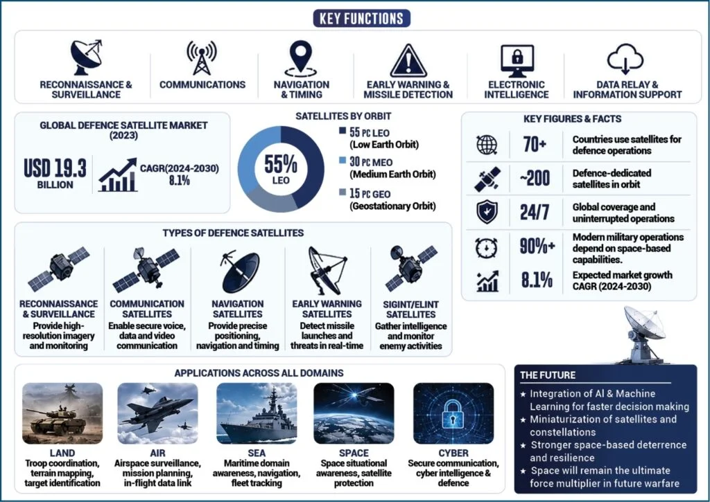
Satellite systems form a key part of Indian modern defence operations
As Kuber notes, ground intelligence remains vital for context and human verification but satellites provide persistent, wide-area coverage a complementary role often and supplementary as a rule.
India conducted its first anti-satellite test, Mission Shakti, in March 2019, but China has possessed that capability longer and has deeply integrated its military satellites with naval, ground and air forces. Cyber threats compound the exposure. The spoofing campaign along India’s western frontier through 2024, in which false satellite signals misled navigation systems, is a low-cost method of degrading satellite utility without physically destroying any asset. Global military space spending crossed USD 80 billion in 2024.
India’s defence budget for 2025-26 is at a record level, with an additional INR 50 billion potentially earmarked after Sindoor for satellite launches and ISR upgrades.
Also Read: Forces face moral dilemma over Artificial Intelligence in defence
Coverage gaps remain the most immediate constraint. The United States and China operate hundreds of ISR satellites providing real-time persistent surveillance. India’s current constellation covers borders periodically rather than continuously. The 52-satellite programme addresses this but full operational capacity arrives only in 2029. The SBS-3 satellite programme has faced delays due to a combination of financial, industrial and logistical challenges. Analysts point to limited large-scale private investment in India’s defence-space sector, structural constraints within the domestic satellite manufacturing ecosystem, and the complexity of coordinating production and deployment of 52 satellites between government agencies and private companies.
“Satellites have transformed India’s defence posture by enabling persistent surveillance, secure communication and early warning. Yet coverage gaps, cyber threats and ASAT risks remain the biggest challenges. The future lies in constellation expansion, AI-driven analytics and hardened cyber-spacе infrastructure,” says Kuber.
The 52 satellites approved last October are a start. Whether they arrive on schedule and whether India’s spасе doctrine is ready when they do will determine how effectively India’s eyes in orbit keep pace with what is developing on its borders.
As warfare increasingly shifts into the digital and orbital domains, satellites are no longer auxiliary assets but central pillars of military power. For India, the lessons continue to shape a strategic push towards self-reliance in navigation, surveillance and secure communications. In an era where borders are watched not only by soldiers on the ground but by sensors hundreds of km above the Earth, India’s growing space infrastructure may well determine how effectively it can anticipate threats, protect its frontiers and project power in an increasingly contested region.