
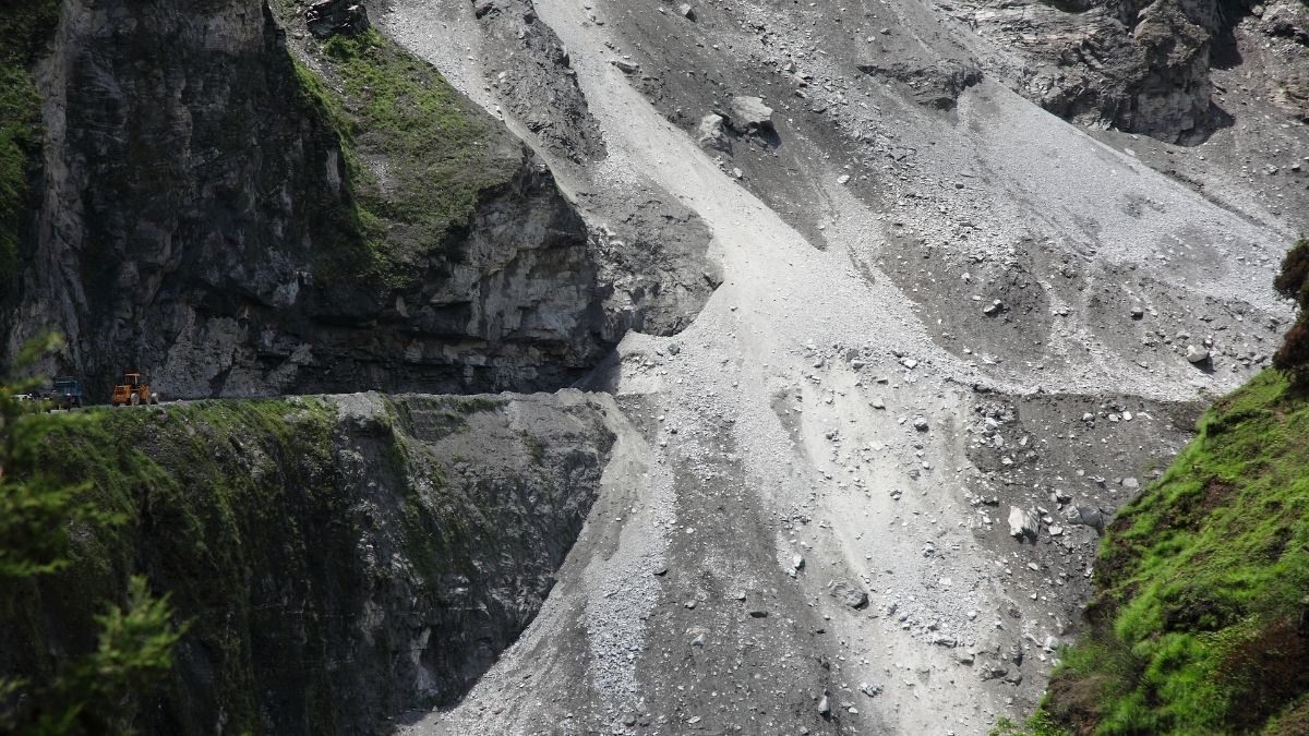
India's mountain regions face rising landslide risks amid recurring monsoon disruptions
From Uttarakhand’s Char Dham route and Himachal Pradesh’s mountain highways to the Bhor Ghat section between Mumbai and Pune, landslides have repeatedly crippled transport even though southwest monsoon remains fairly weak due to El Nino weather phenomenon that has gripped the global weather systems this year.
Even though on an average, the rains have been about 30 pc below normal so far across India, the first spell of heavy rain washed away roads, disrupted rail services on the Mumbai-Pune route, blocked more than 126 roads in Uttarakhand and cut off several Himalayan communities.
Despite over a decade of scientific studies, government hazard maps and disaster management policies warning about the fragility of India’s mountains, landslides continue to increase with every monsoon. Roads are repeatedly blocked, villages cut off, infrastructure destroyed and hundreds of lives lost each year.
While governments routinely blame heavy rainfall and climate change, experts argue that the real crisis lies in the continued destruction of forests, indiscriminate hill cutting, poorly planned road expansion and weak enforcement of environmental safeguards. More than new forecasting systems and policy announcements, India needs stricter regulation of construction, stronger protection of fragile ecosystems and greater political willingness to prioritise prevention over post-disaster relief.
As the southwest monsoon intensifies across the country, the warnings have once again become reality.
On July 12, heavy rainfall triggered landslides across Uttarakhand, blocking 126 roads, including two national highways, while the India Meteorological Department (IMD) issued a red alert. The Rishikesh-Yamunotri Highway remained shut for several days after a landslide near Syanachatti. Earlier, landslides disrupted the Char Dham Yatra at Nalu Pani, blocked the Gangotri Highway and forced schools to close in Rudraprayag as the Alaknanda and Mandakini rivers overflowed.
Also Read:Ecologists blame faulty infrastructure projects for Himalayan landslides
Neighbouring Himachal Pradesh also witnessed widespread damage after landslides and flash floods destroyed roads and bridges around Sirmaur and Nahan, while landslides in the Bhor Ghat section disrupted Mumbai-Pune railway services.
For residents living in the higher Himalayan villages, landslides have become a recurring part of life rather than an occasional disaster.
“Even in the past, mountains used to break during the rainy season, but in the last few years, such incidents are being seen much more frequently. As soon as it rains, the roads get blocked. People’s movement towards Joshimath from Tolma, Malari and Niti Valley gets completely shut down multiple times,” Debu Butola, a resident of Tolma village in Uttarakhand’s Chamoli district, tells Media India Group.
Butola says Joshimath serves as the main market, healthcare and education centre for nearly 20 to 22 villages in the Niti Valley. “Taking a sick person or a pregnant woman to the hospital, children going to school, and even bringing household groceries and rations becomes extremely difficult when roads are blocked,” he says.
These incidents are not isolated disasters. They are unfolding in exactly the regions that government agencies have repeatedly identified as India’s highest landslide-risk zones, raising uncomfortable questions about why development continues largely unchanged despite years of scientific warnings.
India is officially among the world’s most landslide-prone countries.
According to the Geological Survey of India (GSI), nearly 0.42 million sq km, or 12.6 pc of India’s land area, excluding snow-covered regions, is vulnerable to landslides.
The Indian Landslide Susceptibility Map developed by IIT Delhi places the figure even higher at 13.17 pc, with 4.75 pc categorised as very highly susceptible.
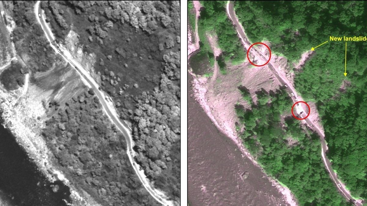
Blockage of road (highlighted with circles) adjacent to the Tista river due to landslides (Photo: ISRO)
The ISRO-NRSC Landslide Atlas of India (2023) mapped nearly 80,000 landslide events between 1998 and 2022 across 17 states and two Union Territories.
According to the ISRO’s National Remote Sensing Centre (NRSC) Landslide Atlas of India 2023, which analysed landslide events between 1998 and 2022, Mizoram recorded the highest number of landslide events at 12,385, followed by Uttarakhand (11,219), Tripura (8,070), Arunachal Pradesh (7,689) and Jammu & Kashmir (7,280).
The Northwest Himalayas account for 66.5 pc of India’s total landslide exposure, while Rudraprayag and Tehri Garhwal remain the country’s most vulnerable districts.
Also Read: Extreme climate incidents on 99 pc of days in nine months in India: CSE
Yet these are also the regions witnessing aggressive highway expansion, hydropower construction, tourism infrastructure and urban development.
According to the National Crime Records Bureau (NCRB), 351 people died in landslides during 2024, while extreme weather claimed 7,903 lives nationwide.
In Kerala, landslides accounted for 155 of the state’s 172 natural disaster deaths, while Meghalaya, Mizoram, Sikkim and Tripura also recorded high fatalities.
In a Lok Sabha reply in November 2024, the Ministry of Home Affairs said floods, landslides and cyclones together killed at least 2,803 people and affected over 1.02 million hectares of cropland during FY 2024-25.
Beyond the loss of life, the Geological Survey of India estimates landslide-related damage can cost 1-2 pc of Gross National Product in landslide-prone developing countries.
While heavy rainfall is often cited as the primary trigger, scientists increasingly argue that human activities are turning natural hazards into recurring disasters.
Government studies estimate that nearly 73 pc of Himalayan landslides are triggered by intense rainfall, a trend made worse by climate change and increasingly erratic monsoon patterns.

Anuj Narula
“India is naturally prone to landslides because of its young and fragile mountain systems, particularly the Himalayas, and the steep terrain of the Western Ghats. These regions receive intense monsoon rainfall every year, but the natural vulnerability is being aggravated by human interventions,” Anuj Narula, an experienced engineer and Founder and Managing Director of Techhub Engineering and Advisors tells Media India Group.
According to Narula, one of the biggest shortcomings in India is the lack of adequate slope preparation and stabilisation before infrastructure projects begin.
Also Read:Indian coasts face fast-moving climate crisis, warns Azim Premji University
“Before constructing roads in mountainous regions, the terrain must be scientifically prepared. Proper slope stabilisation, retaining structures, drainage systems and geotechnical studies should be completed before excavation starts. Unfortunately, in India, these measures are often treated as secondary. It is a very amateurish arrangement instead of a scientific approach,” he says.
Narula points to countries such as Switzerland as examples of how engineering can significantly reduce landslide risks.
“If you look at Switzerland, every mountain road is designed after detailed geological investigations. Slopes are reinforced, drainage is meticulously planned and continuous monitoring is carried out. Infrastructure is built to work with the mountain, not against it. India needs to adopt the same long-term approach instead of prioritising speed over safety,” he adds.
However, researchers say rainfall only acts as the trigger.
The underlying causes lie in deforestation, indiscriminate hill cutting, road widening without adequate slope stabilisation, tunnel blasting, hydropower projects, mining and unregulated construction on fragile mountain slopes.
Large stretches of forests have been cleared to accommodate highways and tourism infrastructure, removing vegetation that naturally binds the soil. Mountain slopes are routinely cut to speed up road projects, often without adequate retaining walls or drainage systems. Tunnel excavation and blasting alter geological stability, while construction continues even in scientifically identified hazard zones.
Butola says residents have witnessed how rapid construction has increased the risks.
“The mountains are very fragile. Building roads is necessary, but where heavy cutting and excavation take place, the danger increases and keeps growing because the work is often not completed on time. The weather in the mountains has also changed significantly over the past few years. Development in the Himalayas should therefore be carried out very carefully and using scientific methods,” he says.
The way hill roads are currently being built often makes already fragile slopes more unstable.
“Once you start widening a hill road, cutting into the bottom or any fragile section weakens the mountain. When heavy rainfall saturates the soil, the hanging mass loses stability and eventually collapses, triggering a landslide,” adds Narula.
Also Read:COP30: Flood of climate finance needed, not a trickle
He says rainfall is only the immediate trigger, while poor construction practices are the underlying cause. “More rainfall means the soil becomes heavier and fully saturated, but without large-scale hill cutting and disturbance, many of these slopes would remain comparatively stable,” Narula adds.
Despite knowing where landslides are most likely to occur, authorities continue approving projects in vulnerable areas.
Narula believes one of the biggest policy failures is the absence of mandatory geological assessments before construction begins.
“Contractors have no mandate under their contracts to scientifically examine the mountain before construction begins. There are no comprehensive engineering guidelines requiring them to assess slope stability first and that is one of the biggest reasons landslides continue to occur,” he says.
According to Narula, India already has the scientific expertise needed to reduce landslide risks, but policymakers rarely incorporate it into infrastructure planning.
“Organisations such as the Geological Survey of India, along with IITs and NITs, are carrying out extensive research on mountain stability. Unfortunately, much of this work remains limited in its application and is not widely integrated into government decision-making. Scientific studies should become mandatory before any road or infrastructure project begins in fragile mountain regions,” he says.
Successive governments have announced multiple initiatives to tackle the problem.
In July 2024, the government inaugurated the National Landslide Forecasting Centre (NLFC) in Kolkata, alongside the Bhusanket web portal and Bhooskhalan mobile application for daily landslide forecasts. The early warning system currently covers Darjeeling, Kalimpong and the Nilgiris, with plans for nationwide expansion by 2030.
While welcoming the government’s early warning initiatives, Butola says the benefits often fail to reach remote communities in time.
Also Read:Interconnected Disaster Risk Report cautions of dramatic changes
“There has been some improvement compared to earlier years. Sometimes we receive information from the Meteorological Department and the administration, but the information does not always reach remote villages on time. If proper warnings are received well in advance, people can postpone their travel and remain safe inside their homes,” he says.
The National Disaster Management Authority (NDMA) has also introduced the National Landslide Risk Management Strategy, the Landslide Risk Mitigation Scheme and the 3M Strategy of Mapping, Monitoring and Mitigation, supported through the National Disaster Mitigation Fund.
On paper, India now possesses one of its strongest institutional frameworks for landslide management.
Yet the disasters continue almost unchanged every monsoon.
Experts point out that hazard maps remain underutilised in planning approvals, real-time monitoring networks cover only limited areas and coordination between the IMD, GSI, NDMA and state authorities remains inconsistent.
Most importantly, construction activities continue largely unchecked.
Narula says preventing landslides is possible if governments shift their focus from post-disaster response to engineering-based prevention.
“Rainfall cannot be controlled, but its impact can. One of the most effective measures is to build proper drainage systems so that rainwater is safely channelled away instead of saturating mountain slopes. Along with scientific slope assessments before construction, better drainage infrastructure can significantly reduce landslide risks,” he says.
Butola believes authorities need to shift their focus from emergency response to prevention.
“First of all, the government should work by understanding the nature of the mountains. At places where the danger is highest during the monsoon, retaining walls, proper drainage systems and slope reinforcement should be prioritised. Weather warnings should be issued regularly, blocked roads should be cleared immediately and, most importantly, the opinions of local villagers should be taken seriously because they understand their region better than anyone else,” he adds.
Also Read: Punjab floods highlight unequal climate burden on vulnerable communities, say experts
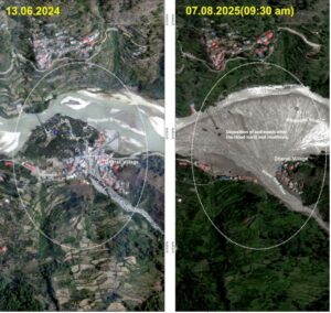
Satellite image of Dharali Flash Flood, Uttarakhand (Photo: ISRO)
Roads continue to be widened through unstable mountains, forests continue to disappear, hotels and tourism infrastructure continue expanding and hydropower projects continue altering fragile slopes, often despite repeated scientific warnings.
The contrast became evident during the 2024 Munnar landslides in Kerala, where early scientific warnings enabled authorities to evacuate residents before major slope failures occurred, preventing fatalities. The incident demonstrated that existing forecasting systems can save lives when governments act promptly.
However, such examples remain the exception rather than the norm.
With several weeks of monsoon still ahead, Uttarakhand, Himachal Pradesh, Jammu & Kashmir, Sikkim and the northeastern states are expected to receive more intense rainfall, increasing landslide risks further.
India has not failed because it lacks scientific knowledge. It has hazard maps, forecasting systems, expert committees and national policies. The larger failure lies in translating those warnings into governance.
Until governments place the same emphasis on regulating construction, protecting forests and enforcing scientific recommendations as they do on announcing new infrastructure projects, landslides will remain less a natural disaster and more a consequence of preventable policy failures.
